I’ve decided to be an adult and accept that I am in southcentral PA until retirement. So the next step of adulthood for me is buying a house. I had only a few criteria for my house: (1) Big enough for all my books but small enough to clean, (2) Within walking distance to work, and (3) Not in the Tropical Storm Lee flood area. I have been working with a great real-estate agent who tolerates all my engineering quirks, which means that I don’t waste her time going to houses that I know won’t work.
So what does Tropical Storm Lee have to do with all of this? First, if TS Lee can happen once in the 13 years I’ve lived here, then it could happen again. I have at least 15 years before retirement. We seem to have more extreme rain cycles over the last few years (more dry days followed by more intense storms). When I moved here, I could see across the street at work during a rain storm. Now there are southern gullywashers where, for a few minutes, all I can see is the rain. I see much more flash flooding where the gutters and inlets can’t keep up with the rain. TS Lee first had flashflooding (which easily could happen anywhere in any town) and then river flooding as the crest moved down the Swatara Creek. It is the river flooding I am avoiding.
I had gone back and forth on a house because it was on the border of the flood zone. One older map said no and one newer map said that a corner of the property may touch the flood zone (you can check your location in PA here: http://www.pafloodmaps.com/homeowners-tenants/Pages/default.aspx#.WCeKHWorLIU, then find the link part way down the page that says Flood Risk Application Tool). In the area of Middletown where I was house-hunting, here is the map. So as cute as some houses were, nope. Yes, you can buy a house in a floodplain. Yes you can build in a floodplain. However, even with the rules in place for special requirements to build in a floodplain, I think we are incredibly foolish to build new structures in areas that Mother Nature intended to use to soak up water into the ground, replenishing groundwater and hopefully keeping it out of the streams, which reduces flooding.
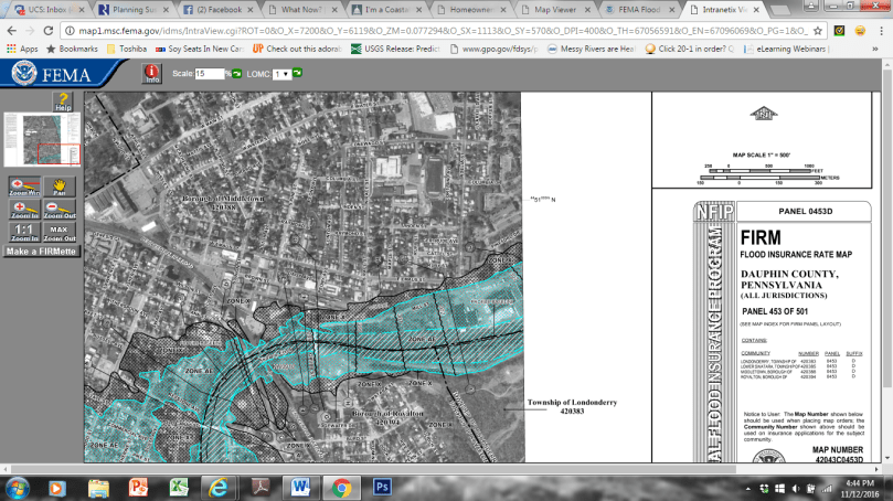
I looked at this map again and I realized that this map, which was in production during TS Lee, put TS Lee flooding levels in the 100-year to 500-year floodplain (a 100-year storm is one that has a 1% chance of happening in any year, while a 500-year storm has a 0.2% chance). Many areas that are slightly outside or on the edge of the the 500-year floodplain were flooded. I walked the town and I saw this (missed the peak of flooding because it occurred overnight).


Mill St. Flooding levels between 100-year and 500-year floodplain (Moose Lodge Parking, September 8, 2011 [left]; Mill St High Water Mark, September 9, 2011 (center); Mill St under water, September 9, 2011 [right])


Race St Flooding by Hoffer Park. Left: September 8, 2011; Right: September 9, 2011 (with a large increase in the inundated floodplain)


Left: Flooding behind houses on Emaus St.; Right: PA 230 at Swatara Creek bridge underwater.
A storm, that was not a 1% chance storm by definition, caused flooding that had between a 0.2 – 1% chance of occurring. And those aren’t odds I’m willing to live with, given the changes I’ve observed in the rainfall patterns. I’ll be in my new house, high and dry.
More to come on why TS Lee overwhelmed the drainage system in a slightly more technical, non-technical way soon!
